

Greensand Way stage 4: Dorking to Earlswood
- Kate Cheema

- May 29, 2020
- 4 min read
Updated: Jun 28, 2020
With the slight easing of restrictions I took the opportunity of my last day off work to tick off the next stage of the Greensand Way. This time, it’s squarely on home turf, taking in the 17km between St Paul’s Church on St Pauls’ Road West in Dorking to the junction of the Greensand Way with National Cycle Route 21 just south of Earlswood Station.
Initial plans did not go well; a car accident all but shut off the road into Dorking and the good web-developer-him-indoors (being on the clock) was forced to drop me about 6km short of my starting point. So I kicked off instead at Betchworth train station, with the niggling knowledge that at some point I will have to go back and cover that missing 6km, now a glaring gap on my overall course. In all I covered 12.2km of the Greensand Way in 2 hours 30 minutes.
In the bag:
1.5ltr bladder of water
Tea, earl grey, hot
No lunch, but snacks of dried fruit and a banana
Suncream, lots of suncream
Today’s map:
Entirely on OS Explorer map 146
From Betchworth station I headed south, following the road for about 1km to meet the intersection of the Greensand Way just the other side of the Dolphin pub and opposite St Michaels Church (13th century, featured in Four Weddings and a Funeral). Betchworth village is just beautiful, dripping with a sense of history and plenty of house envy.

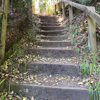
As always the GW is well waymarked; initially following country lanes, the path takes a sharp right at the end of Sandy Lane and goes up steps into open country. This is horsey country, so the path passes lots of stables and through fields with livestock.


Whilst you won’t be able to see it, the path takes you to close to the shores of Buckland Park lake (a great place for an outdoor swim!); following lane round the southern side of the lake you’ll pass through Dungates Farm (wave to the labradors) and then through pretty woodland and fields over to Reigate Heath. You’ll cross the golf course, headed towards the club house and windmill next to it.

Head up a small slope, which brings you to the golf club car park. Turn left and head up past the club house. The GW takes a right turn off the driveway and is not waymarked; it’s an obvious path but check the map to ensure you’re on the right track. If you‘ve reached the overflow car park you‘ve gone too far!
The path takes you through heathland down to Flanchford Road; cross this and head up the drive of the White House. At the top of this driveway the GW turns into a narrow footpath; this can sometimes get obscured by parked cars so if it’s not obvious keep looking! Follow the path around houses until you come out by the Skimmington Castle pub.

The other side of the pub car park (head straight across the front of the building) rejoin the GW, heading right. Follow the path through farmland and past stables until you meet Littleton Lane; this then comes to a T-junction with Park Lane. cross the road and then head straight up the steps to the path that runs around the hill of Reigate Park. Don’t be fooled into thinking you get to turn left or right on these docile looking paths, the GW heads straight up, taking in 30m of elevation in about 80 metres. Its a tough but short climb and well rewarded with views from the top of the hill. This is Reigate Park; at the bottom of the hill is Priory Park which has lots of wide open space and in usual times a childrens playground, skatepark and cafe.

Head straight ahead over the top of the hill, a wide avenue between trees with lots of opportunities to stop for a breather (you’ll need it after that hill!), and follow the path down the hill, eventually coming out onto the A217. Cross the road and turn right, following the road until you reach Isabell’s Drive. Head up this and follow the road and then path round to the right. You’re now firmly in suburbia!
On the whole the GW is reasonably well waymarked here, guiding you through the maze of footpaths and shortcuts. However, there is a bit of a fail when emerging from Furzefield Road; for reference, head right down Cronks Hill, turn left onto Cronks Hill Road following the road round to the right and then follow the first ‘public footpath‘ sign to the left that you see.


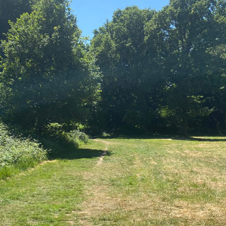
The GW is better signed from here and takes you down onto Earlswood Common. This is a beautiful chunk of green space with loads of nooks and crannies to explore and relax in. The GW takes you straight through it until you reach Earlswood lakes.


Pick up the path heading left around the lake once you reach the lakeside and stick to it past the lake, and then over open space until you reach the A23. The path officially takes you left up the A23 before crossing over, but it’s a bit nicer to cross directly and follow a path over grass, heading round to the left following the field boundary until reaching a tarmac footpath. Turn right on this and head under the Asylum Arch Road railway bridge. This brings you out onto cycle route 21 and where we leave the path today.
It maybe because I’m too familiar with this route, or maybe because of the foiled plan at the start but this was my least favourite leg so far. Because its the bit of the path that passes through the busy London-to-Brighton road links it’s the most built up bit on the whole route and I much prefer open country.
Here’s the map....(with an extra 6km tagged on because I walked home).


Comments