
Greensand Way stage 5: Earlswood to Limpsfield Chart
- Kate Cheema

- Jun 28, 2020
- 5 min read
A glorious day for a ramble about the place; sun but not too hot, and a decent breeze. This was a really lovely stage, still relatively built up areas but absolutely showcasing the lovely bits of East Surrey. I started at Earlswood Station (looking like I was robbing the stage) and ended at St Andrew’s Church at Limpsfield Chart, about 23km (14.2 miles) in all, which took me, including lunch, a little over 4 and a half hours.

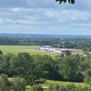
You rejoin the GW at the bottom of Princes Road and head off through mixed woodland and narrow paths skirting around Earlswood Park until finally emerging into open countryside, heading uphill towards Garstons House. The path runs between fields of livestock and already gives hints of fabulous views to come off to the right. Crossing a byway, you follow the path into miles of fields that at the moment have broad beans growing in them (shame, I can’t stand broad beans) peppered with pill boxes. Following the bean fields comes the first of a number of short stints on the road. Passing Kings Mill on the right and heading over Clay Lane the path follows the road up (and up and up!) to the wonderfully named Hogtrough Lane. Take a pause (you’ll need it) and then follow the GW off to the left, a narrow path tracking above Bray’s Farm and giving the first beautiful view out over farmland and with the aerodrome in the distance!


The narrow path eventually brings you down on the main thoroughfare for South Nutfield, a pretty village where the shop is a purveyor of the finest bread pudding known to humankind (I might have mentioned it before!). A short walk through the village leads to a byway which brings you back out into open country and a wide range of footpaths and local routes that include the Tandridge Border Path. A this point it‘s worth mentioning that the waymarking for the GW in this section is not as good as it is elsewhere; mostly this isn’t an issue as the GW follows the ‘obvious’ footpath, but there are occasions where a number of other paths intersecting make a map or app a must have for this stage. The GW heads up towards Lyttel Hall, a large building which is now private homes but was the former HQ for the Brewing Industry Research Foundation. Mysterious.
Following Coopers Hill Road south for a bit, the GW then turns left to go under the M23 and emerges into wide open fields with livestock roaming (sheep) and huge ancient oaks scattered across the expanse. The path is not waymarked GW but is an obvious one, heading north until reaching farm buildings where it becomes a bit bewildering because there are no fewer than five ‘public footpath’ fingerposts, not one of which has GW indicated! The one you want is on the left, over a stile, then tracking between fences, climbing up the escarpment. It’s a bit of a slog but so worth it when you get to the top!

The GW comes out on Outwood Lane, just south of Bletchingly, and carries on past Hevers Pond (a sanctuary for great crested newts and toads by all accounts) and then tracks along the escarpment just above Gravelhill Wood, which I suspect provides a clue to the nature of the ‘disused workings’ shown on the map. I went a bit wrong here, again due to inadequate waymarkings, although it was still a pretty diversion through an open field with families out for a picnic. I did set myself right (through judicious use of the ever excellent OS app) to rejoin the GW and head into Tilburstowhill Plantation. With a stiff breeze the sound of the trees was very soothing, and the shade very welcome; the woodland consists predominately of sweet chestnut coppice with a mix of oak, beech, silver birch and hazel. It’s very lovely.
Heading out of the woods the GW tracks through the most magnificent field of wheat (seasonally obvs); standing lonely in the centre of the field are the footpath fingerposts.

A bit more road walking after the wheat field, the heading round Leigh Place Pond (much fly fishing to be had if the signs are to be believed) then through open fields towards Tandridge. This is still mostly farmland, not especially interesting but still with the characteristic ‘greensand’ clearly visible underfoot. The GW passes through Tandridge and heads over to Oxted through fairly enclosed paths going over more farmland (more wheat) and arriving at the southern boundaries of Oxted parish (pretty much Hurst Green). I stopped for lunch here, perching on a bench under an oak tree off Broadham Green Road, before heading onwards, following the GW (also at this point the Greenwich Meridian Trail) up towards Oxted Mill.


Oxted Mill stands on the River Eden. The site of the mill was mentioned in the Domesday survey in 1086. In Victorian times, Oxted Mill was in fact two self-contained flourmills which were attached to each other. Flour milling ceased here in August 1951, and the machinery was removed and the building converted. You can also get married here! There’s a decent linear walk from Woldingham to Hurst Green station that takes this in too, in case you fancy something shorter.
Following the GW up Mill Lane (don’t be tempted by the other paths nearby!) the path snakes through south Oxted largely behind houses and between gardens, emerging into grassland to track the edge of the western part of Limpsfield Common. After a bit the path plunges into the main body of the Common which is a beautiful bit of ancient woodland, with lots to explore including local air raid shelters and a BMX track that would make my sons very happy.

The final part of my journey skirting Tenchley’s Park and heading towards Limpsfield Chart gave me my last spectacular views of the day. At this point we’re looking at the Weald of Kent and just a hint of the glories to come as the next stage takes me over towards Sevenoaks.
I headed into the village of Limpsfield Chart and easily found the pretty church of St Andrew’s where the good web-developer-him-indoors was waiting (lurking on a bench) to take me home. It was nice to see all the places I had walked though referenced by signs off the main road and reflect that on foot is really the best way to see Surrey for the beautiful county it is.
This stage is an important one in the overall Greensand Way mission; I’ve passed the half way mark. I’ve done about 93km in total, that’s just over 57 miles, and the GW is 180km (110 miles) end to end. In fact I reckon that Oxted Mill marked about halfway. Secondly its my last leg that is just in Surrey. Over the 5 stages I’ve more or less covered the the width of Surrey (Haslemere is a mere handful of miles from the Hampshire and West Sussex borders, the most southerly town in the county) so I’m looking forward to getting stuck into my home county (what, you thought I was Surrey born and bred!?). Onwards, to the Garden of England!
Here’s the map.....

And here’s the cat. With this blog. Very meta.....


Comments